Geospatial and urban development
Following the trend of the Bangkok governor election, many of you may have seen interesting policies for urban development with the concept of applying technology to develop Bangkok to be a “Smart City”
.
“Bangkok” is a special area for administration with complex problems in various dimensions. The city has high spatial dynamic change and the city is a multicultural city that expands fast. Meanwhile, the complex problems are also being increased. The challenge of managing the city is not only to solve the problem but also to comprehend the differences between areas which is the most important point, to begin with. This is because each district has different problems. Thus, the integration of geospatial data is the key to stepping into a “Smart City” where “Geo-informatics Technology” will be the supporting tool to see the overview problems of Bangkok.
.
Understand the city with geospatial technology
.
Geospatial technology plays an important role in terms of area development for a long time. The variety of complex areas is gathered and stored in the form of a map from the scope of administration, city design, utility, transportation, tourism, industry, public space, land usage, to drainage and flood protection system. This enables us to see the relationship patterns of all phenomena, and relevant problems so as to plan for area management that has complexity, and analyze resource allocation, budget planning, and city planning.
.
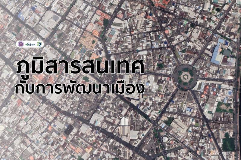
Looking at Bangkok through a geospatial lens
.
The geospatial data from multiple sources in Bangkok has shown that “Bangkok” has a continuous expansion of settlements from urban areas to suburban areas. With the density of the increased population, it impacts different areas in which we can see that some district has a higher living cost and the slum area can be particularly dense. Moreover, the access to public health services and transportation might not be similar for each district which clearly shows inequality.
.
The geospatial data of Bangkok are continuously being stored by relevant agencies to use for analysis and planning for flood protection, disaster alleviation, slum area management, outbreak cluster management, utility services, tax map management, and public health services as well as economic planning for suitable areas. Thus, geospatial data is important to see the overview part and plan for the right solution.
.
Geospatial and urban development
.
The concept of Bangkok’s development to be a smart city is not a new thing. Several agencies have studied and are working in pilot areas. Geospatial information is applied in conjunction with high-speed communication networks, Internet of Things (IoT) technology, data from crowdsourcing, and Big Data to improve the data efficiency and analyze the spatial area at a high level for accuracy of the forecast. This also can be processed in real-time for public participation and decision-making to solve problems in a timely manner.
.
It can be said that geospatial technology is one of the important tools for city development on all levels from planning the structure of high-speed public trains, utility networks, economic and industrial management, and public health service, to small levels like waste management in a community. This is because linking all data together is the important key to learning about area relationship patterns.
.
The innovation of spatial technology and city development to reduce area inequality.
.
Actionable Intelligence Policy or AIP Platform that GISTDA is striving to develop a policy innovation in spatial management. It combines data from multiple sources to process, analyze and forecast trends together with modern technologies, both Artificial Intelligence (AI) and Machine Learning to find and extract insights on targeted areas and populations to make policy decisions based on evidence (Evidence-Based Decision Making) to design appropriate development guidelines, addressing spatial problems and bring it into practice
.
Today, AIP platform has developed and solved different kinds of problems including poverty, inequality, agriculture, and environmental issue in Naan province as well as planning for economic structure and managing the environmental impact in EEC area, which will continue to develop in other areas also in the future.
.
In addition, GISTDA is developing an “open platform” the source of big spatial data, especially from satellite images to be one of the supporting tools for spatial analysis in which users do not have to download the satellite images as each area has differences. Especially Bangkok is complex so it needs more understanding in order to make any decision for city development with high efficiency. As the saying goes “The right data makes the right strategies.”
.
#GISTSAinits22ndyear #GISTDA #Space #Geoinformaticsandurbandevelopment #GovernorElection #Bangkok #Smart City #spatialchange #understanding #problemcontext #map #townplanning #utilitiesnetwork