Field Server: Weather Data and Daily Agricultural Image Collection System
Thailand is an agricultural country and the most important food production source of this world. The application of Geographic Information System (GIS) and Remote Sensing to follow-up, evaluate products or even predict the products in advance is crucial to agricultural system management administration for constant and sustainable development.
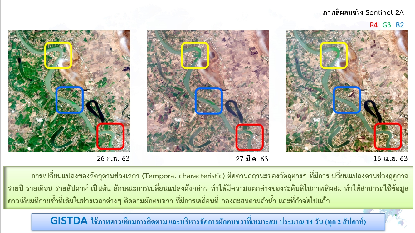
Aerial photograph is therefore very useful information to follow up situation of agriculture in the wide areas (at provincial or national levels). However, accuracy check is another importance process to ensure correctness of aerial photograph interpretation. At present checking accuracy of interpretation can be done in many ways: surveying samples or using data from supporting systems such as aerial photograph, images from Unmanned Aerial Vehicle (UAV) to check and adjust some mistakes. Please imagine how nice if we have automatic recording devices at our agricultural areas to check devices instead of using staff. It is continously long-run used and report situations in almost the real time.
GISTDA began this project in 2012. We installed devices called Field Server** to collect data from agricultural areas. At present there are 24 stations installed in several areas in all around the country (Figure 1 left). There are a wide range of economic crops and others such as rice, sugar cane, cassava, asparagus, etc. The recorded data is divided into two parts: daily image data and weather data, which is connected and sent to central network through mobile communication (Figure 1 right)

Figure 1 Installing Positions of 24-station Field Server (left) and Connection System to Central Network (right) in 2015-2017
There will be the expand of Field Server covering more areas for 72 stations with the total of 96 stations

Figure 2 Filed Server: A) Controlling Unit, B) Camera and C) Weather Measurement Device
Filed Servers are shown in Figure 2: A) Controlling Unit commands the camera and weather measurement device to record the data and sends it to the central network, B) Camera takes images twice a day. One image is spare for unexpected cases because of rain water, fog, steam, or other materials concealing the camera screen. Examples of images from 24-station Field Server are presented in Figure 3 and C) Weather Measurement Device is commanded to record the data in every five minutes. This data relates to humidity of air and soil, light intensity, quantity of rain water, temperature, speed and directions of wind. The daily image data and weather conditions are absolutely useful to create agricultural condition following-up system, product prediction system, disaster decrease from plant epidemic, etc. If the daily image data is compared with the satellite images in the same area, it can be used to check accuracy of satellite image interpretation, including effective calibration. Moreover, Field Server is certainly agriculturally applied as Smart Farming or Precision Agriculture in the near future.

Figure 3 Samples of Images Recorded by Field Server from all 24 Stations
Next step, we will probably see how the image data from Field Server can be used to develop Automatic Rice Plot Condition Following-up System, which enables us to see prospective agricultural helping systems monitoring the growth of rice from being rice sprouts, growing, producing grains to being harvested.
**GISTDA is responsible for installing Field Server developed by NECTEC and processing data.
Field Servers are recording devices directly record data from agricultural plots. They are installed at agricultural plots around the country since the rice is an economic plant and staple for Thai people. Rice plots get priority to be emphasized. Total number of Field Server station is 24. Ten of them were directly installed at the rice plots. a
In Section 2 we are seeing how daily images are used to follow up and classify rice plots. If considering the recorded images in 2014 at the rice plots in Supanburi province as shown in Figure 1, it indicates that the rice plots are roughly divided into 4 conditions b: rice sprouts, growing, producing grains and harvested. One important difference that is obviously seen from the images in every condition is reaction levels of green plants:
1) rice sprout – light green 2) growing – dark green
3) producing grains – golden yellow 4) harvested – brown (rarely green)
Note
a 10 rice plot locations that Field Servers were installed, are presented by ‘Station Number (province)’: 01 (Supanburi),04 (Roi-ed),12(Nan), 13 (Chiang Rai), 15 (Phatthalung)19 (Angthong),20 (Angthong), 22 (Ubonratchathani), 23(Pathumtani), 24(Rayong)
b Conditions roughly divided (based on interpretation of general people) to set up automatic daily image processing program to classify conditions of the rice plots

Figure 1 Recorded Image by Field Server at the Rice Plot in Supanburi Province in Different Time and Place
If thinking about a technique for analyzing images, calculating reaction levels of green plants in each image, it is generally referred to “Vegetation Index” that indicates conditions of rice plots at the recorded time. In case of having a set of images in a specific duration of time, presenting calculated Vegetation Index from each image on time axis c, Vegetation Phenology, as shown in Figure 2 by the use of Image Time Series for analysis causes more effective and accurate of following-up and condition classification of the rice plots than the use of Vegetation Index from only an image.
Note
c Time axis normally refers to Day of Year (DoY) value. In 2014, DoY = 1 means 1st Jan. 14, and DoY = 365 means 31st Dec. 14.
Figure 2 presents characteristics of Vegetation Phenology calculated from out-of-season rice plots which has two rounds a year. Information about round numbers of planting is from the increase of Vegetation Index from the highest one and its decrease based on time change, which causes a pattern of wave signal. It means one round of rice planting considered by Vegetation. In Figure 2 there are two wave signals that means two rounds of planning.
Small wave signal that has sharp peak in short time might be caused by weed growing during waiting for the new planting round.

Figure 2 Vegetation Phenology of Rice Plots in Supanburi Province in 2014 (Two Rounds of Out-of-Season Rice Planting a Year)
If we know when planting occurs, Vegetation Phenology in each planting round is continuously used for following-up and condition classification of the rice plots. An example of used graphic analysis is under graph area calculation, measurement of appropriate Vegetation Index level for references towards rice plot conditions, etc.

Figure 3 Vegetation Phenology of Rice Plots (see Figure 2) and Recorded Images from Field Server in Different Time
Figure 3 presents Vegetation Phenology and recorded images from field server in different time. An example of rice plot condition classification can be explained as follows:
If Vegetation Index is a bit higher than the lowest value, the upward graph indicates the status of ‘rice sprouts.”
If Vegetation Index increases to high level, it means ‘growing’ status.
If Vegetation Index decreases from the highest one, it means ‘producing grains’ status.
If Vegetation Index is a bit higher than the lowest value, the inward graph indicates the status of ‘harvested.’
These assumptions can be used to set up Automatic Vegetation Phenology Graph Analysis Program. The technical details will be explained in the next section.
In the next section, we will mention more on Vegetation Index used for reaction level calculation of green plants. We will know how to calculate Vegetation Index of daily rice plot images from Field Server.
Recently, we have mentioned on the use of calculated Vegetation Index from daily images from Field Server to present in Vegetation Phenology, which is really useful for following-up and rice plot condition classification as shown in Figure 1.
How can we calculate Vegetation Index of images from Field Server?
If mentioning on reaction level calculation of plants (green), Normalized Difference Vegetation Index (NDVI) is generally used for satellite image calculation. It is popular Vegetation Index that is calculated though the formula as follows:
NDVI = (NIR – R) / (NIR + R)
NIR (Near-infrared) means digital number values in Near-infrared waves
R (Red) means digital number values in red Near-infrared waves
High level of NDVI means abundant plants (green plants)

Figure 1 Vegetation Phenology Graphic Model Calculated by Time-Series Comparing with Several Conditions of Rice Plots
You may know that the satellite images normally consist of varied wave length data (including NIR and red wave length), so it can be used to calculate the NDVI value. However, the images from Field Server are recorded in the form of RGB or red, green and blue (without NIR wave length), Vegetation Phenology refers to Excessive Green (ExG) that is used for green level indication from RGB images. It can be calculated by the formula as follows:
ExG = 2g – r – b
r normalized value of red wave length calculated from r = R / (R+G+B)
g normalized value of green wave length calculated from g = G / (R+G+B)
b normalized value of blue wave length calculated from b = B / (R+G+B)
RGB Digital Number in red, green and blue wave length
High level of ExG means abundant plant (green plants)
You may wonder why Normalized RGB is used.
It is because daily agricultural images, environment or conditions of light always changes such as sunny and cloudy sky. The normalized value decreases effects from light disturbance, and it also causes more effective of Vegetation Phenology calculation.
If you prefer to say that it seems to consider only color element without considering the change of light, it is absolutely right. Figure 2 presents normalized green and its differences when considering by RGB, but it has the same value when considering by Normalized RGB.

รูปที่ 2ตัวอย่าง (ค่าสีเขียว) ค่า Normalized RGB เพื่อลดผลกระทบของการเปลี่ยนแปลงทางแสง
Noteเทคนิคที่ใช้ในการลดผลกระทบจากการเปลี่ยนแปลงทางแสงนี้ เป็นเทคนิคพื้นฐานโดยทั่วไป สามารถใช้ค่า normalized RGB หรือ ใช้ปริภูมิสีที่มีการแบ่งแยกองค์ประกอบทางสีและแสงอย่างชัดเจนก็ได้ เช่น HSI (Hue, Saturation, Intensity) ในการพิจารณาก็จะแยกองค์ประกอบของ Intensity (ความเข้มแสง) ไป ไม่ได้ถูกนำมาพิจารณาร่วมด้วย เป็นต้น

รูปที่ 3เปรียบเทียบ Vegetation Phenology ที่ได้จาก ExGโดยใช้ ค่า RGB (ปกติ) และค่า Normalized RGB
เมื่อเราคำนวณค่าดัชนีแบบ ExGจากรูปภาพ Field Server ที่ถ่ายได้ปี 2557ณ แปลงข้าวนาปรัง จ. สุพรรณบุรี“โดย 1 รูปภาพ แทนด้วย 1 ค่าของดัชนีแบบ ExG” และนำมาเรียงลำดับในแกนเวลา จะได้เป็น Vegetation Phenology
ในรูปที่ 3เป็นการเปรียบเทียบระหว่าง Vegetation Phenologyที่คำนวณได้จากค่า RGB ปกติ (รูปที่ 3 บน) และ ค่า normalized RGB (รูปที่ 3 ล่าง)จะเห็นได้ว่ากราฟ Vegetation Phenology ที่ได้จากค่า normalized RGB (รูปที่ 3ล่าง) รูปคลื่นมีการสวิงขึ้น-ลง ที่น้อยกว่า‘Smooth กว่า’กราฟที่ได้จากค่า RGB ปกติ (รูปที่ 3บน)จึงกล่าวได้ว่า การใช้ค่าNormalized RGB มีประสิทธิภาพดีกว่าในการลดผลกระทบจากการเปลี่ยนแปลงของแสงที่เกิดขึ้นเมื่อเปรียบเทียบกับการใช้ค่า RGB ปกติ สำหรับกระบวนการหลังจากนี้ กราฟ Vegetation Phenology ที่ได้ จะถูกนำมา Smooth อีกครั้งด้วยตัวกรองความถี่ (Filter) ซึ่งจะได้กล่าวถึงเทคนิคที่ใช้ต่อไปในภายหลัง
Noteเราได้กล่าวถึง ดัชนีแบบ ExGซึ่งในความเป็นจริงแล้ว ยังมีดัชนีแบบอื่นๆ ที่สามารถใช้ในการคำนวณการตอบสนองของพืชสีเขียว สำหรับช่วงคลื่นที่มองเห็นได้ (Visible wavelength “RGB”) เช่น ExGR (Excessive Green-Red),NGRDI (Normalized Green-Red Difference Index) เป็นต้น [2]
ในตอนหน้า เราจะมาติดตามกระบวนการทำงานในแต่ละขั้นตอนว่า ในภาพถ่ายที่ได้จาก Field Server ภาพหนึ่ง ซึ่งประกอบไปด้วย ท้องฟ้า แนวเขา และ แปลงข้าว จะสามารถแยกส่วนเฉพาะ “แปลงข้าว” ซึ่งเป็นบริเวณที่เราสนใจ (Area of Interest) แบบอัตโนมัติได้อย่างไร ?… แล้วพบกันครับ …
เอกสารอ้างอิง
[1] Woebbecke, D. M., Meyer, G. E., Von Bargen, K., Mortensen, D. A. “Color indices for weed identification under various soil, residue, andlighting conditions”, Trans. ASABE 1995, Vol. 38, 259-269.
[2] N. Soontranon, P. Srestasathiern and P. Rakwatin, “Rice Growing Stage Monitoring in Small-scale Region Using ExG Vegetation Index”, in ECTI-CON 2014, NakhonRatchasima, Thailand.
บทความโดย : ดร.นรุตม์ สุนทรานนท์